Volunteer Monitoring of Nuclear Contamination under the Sea
Organization
Dr. Nobuhiro Shiotani, Professor Emeritus
Tokyo University of Fisheries
Representative Director of EcoStudies Association
Dr. Hideo Ohashi, Professor Emeritus
Tokyo University of Marine Science and Technology
Deputy Director of EcoStudies Association
Tokyo, Japan
Problem
Study contamination of terrestrial and marine ecosystems in the aftermath of the Fukushima nuclear accident.
Solution
Develop specialized equipment and monitoring methods for studying radioactive contamination and make the information public so that citizens can make an objective assessment of the present status of contamination.
“Back to 1992, as a member of Institute for Cosmic Ray Research of the University of Tokyo, I visited Germany for my research and a German researcher told me about the Origin software. So, I’ve been using it since then.” - Ohashi
The following case study was submitted by Japanese Origin distributor LightStone Corporation. Lightstone has provided sales and support for the Japanese-language version of Origin, for nearly twenty years. We thank them kindly for giving permission to publish this case study on our website.
About EcoStudies Assocation†
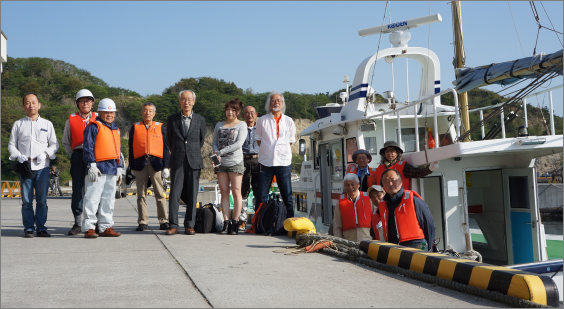
EcoStudies Association is a volunteer group which is working near the nuclear accident-stricken site in Fukushima Prefecture. The organization consists of around 40 members -- researchers, engineers and technicians -- who are mainly either retired or semi-retired, along with some additional young volunteers. The group provides the free service of members’ professional experiences and expertise to local people - monitoring and assessing the radioactivity and its contamination in the area affected by the meltdown of the Fukushima Daiichi Nuclear Power Plant -- upon request.
Seven years have passed since the horrible nuclear disaster in Fukushima has struck the area and since that time, many evacuees have resettled in safer locations. Consequently the number of requests from residential areas for the Association’s services has very much decreased, recently. The radioactivity level of fish caught by official monitors has also recently fallen to within the national health standard, allowing commercial fishing to resume. However, in the natural environment, causal processes involving contamination beyond our current knowledge, may be taking place behind the scenes and we cannot predict exactly what people might face decades from now. So, we have decided to tackle a long–term project for future generations – to record the residual radioactivity on the bottom of the offshore reef close to the nuclear power plant site. For this purpose, we have developed a new radiation detection system to record and accumulate radioactive data in this area.
Accurate Visualization of Radiation Data from the Field Research
LightStone: First, could you please tell us how you started your organization and its work?
Professors Shiotani and Ohashi: After the nuclear disaster at Fukushima Daiichi Nuclear Power Plant, many people raised serious concerns about the harmful effects of radioactive substances on both human health and the ecosystem. However, at the time no one knew what sort of data might actually serve to verify such harmful effects. In addition, we found it necessary to design our own methods of field research, to obtain such data. Our idea was that if scientifically verified data were to become available to people, they could make well-reasoned decisions based on the expected effects and make their own life choices.
Previously, we worked in another organization, but we envisioned having complete independence from the national government and commercial companies, thus allowing us to fill a new niche. So, in 2015 we established a new organization, EcoStudies Association, whose core mission was to carry out radioactive field studies for people within the disaster zone.
L: It sounds like a truly down-to-earth NGO, isn’t it?
S&O: That’s right! We have first tackled monitoring the contamination level inside and around the houses of local residents within the area of the accident site. Subsequently, we shifted the primary focus of our research activities to the sea because of another highly-concerning issue: as radioactive substances are diffused through sea water, they may harm the marine ecosystem. As you probably know, there are various governmental institutes and universities which are conducting official research projects. However, because of the large size of their research vessels, they often have difficulties making a close approach to the rocky coastal reefs inhabited by many varieties of marine organisms. So, at the time, no research had been conducted in such regions by anyone, as far as we know.
L: My assumption would be that fish and other marine organisms would have been negatively affected by the radioactive contamination. Did it actually occur?
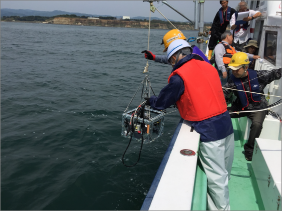
S&O: First of all, to measure the radiation securely we designed a system to take a caesium iodide, (CsI) detector down onto the rocky seafloor from our boat, and with the cooperation of the detector manufacturer, we tested detector performance in the under-sea environment. When we felt that we had gotten satisfactory results, we commissioned a large-sized practical detector. After the nuclear accident in Fukushima, radioactive caesium would likely have settled onto the bottom of the sea near the power plant. There, it was probably absorbed by clay-sized particles and deposited on nearby seashores. As fish and seaweed cannot digest these clay materials, it is possible that these marine organisms were not contaminated in terms of the food safety level. But, we haven’t yet obtained convincing results.
L: How hard is it for you to conduct your research at sea? Could you please describe some of your experiences?
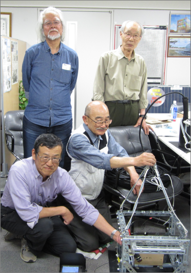
S&O: Before our retirement, although both of us were faculty members of the Department of Marine Environment of Tokyo University of Fisheries (editor: later renamed to Tokyo University of Marine Science and Technology in 2004). I (Shiotani) was doing research in material science and I (Ohashi) was developing cosmic dust detectors on board satellites in space. So, at the beginning of this project, the sea was a completely new environment for us and we were both novices when it came to measuring systems in marine environments.
The first equipment we started using in September 2015 was like a toy system compared to the level of our current system. From the beginning of the project, we had our share of miserable failures: one time, flashlights on the equipment were ripped off when we struck a rock. On another occasion, the video camera on the system was soaked by seawater when the container leaked; and so on! Despite that, each time that we failed, we overcame our problems and improved our system.
“From the beginning of the project, we had our share of miserable failures: one time, flashlights on the equipment were ripped off when we struck a rock. On another occasion, the video camera on the system was soaked by sea water when the container leaked; and so on! Despite that, each time that we failed, we overcame our problems and improved our system.”
In April of this year, we made the system even better by obtaining a new and larger detector. The new sensor has 16 times the detection area of the previous one; the diameter has increased to 4 inches from merely an inch. So, now we can make much faster measurements of radioactivity. Additionally, this new system brought an unexpected bonus. As you can imagine, the reliability of the data from the detector is very much affected by the quality of the contact with the seafloor, and the new detector has made it possible to quantify the degree of attachment by measuring the intensity of radioactive potassium which is fairly evenly distributed at the bottom of the sea in this area. This was never possible to measure using the old small system.
Now, the cage of our current system, constructed with stainless-steel L-angles has many peripherals in addition to the main detector: two live-cast video cameras, two recording video cameras, and four spotlights. Furthermore, we have attached an attitude sensor which can report the current tilt and direction of the equipment, and a fish sonar device to give us some indication of surface features (i.e. rocky vs. sandy) by sensing reflection of ultrasonic signals. With all of the additions, the equipment now weighs in at a heavy 40 kg!
Although it’s hard work to raise or lower this heavy instrument from the boat deck, we have solved the problem with helpful advice from a friend with a lot of experience and know-how in rock-climbing. To hoist the equipment, we use a winch on the boat, a local fishing boat generously provided to us by its captain. We are also lucky and really thankful to have two wonderful members who are engineers. They always miraculously fabricate equipment and things which work wonderfully despite our sometimes wild requests.
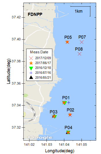
Regarding the safety of our field activities, whenever we plan an experiment on the sea within a 5km (3 mile) radius of the nuclear accident site, we submit our schedule and the site location to the Japan Coast Guard beforehand. So, while we are working on the sea, they can monitor our boat from a certain distance to ensure our safety.
Origin is a Versatile Tool that Meets Our Needs
L: Could you tell us how you started using Origin, and how you currently use it?
O: Back to 1992, as a member of ICRR (Institute for Cosmic Ray Research) of the University of Tokyo, I visited Germany for my research, and a German researcher told me about the Origin software. So, I’ve been using it since then.
S: When I was a member of the Institute of Physical and Chemical Research in Japan, RIKEN, I started using Origin for my work. Origin has been my tool for so many years!
“ Initially, we were seeking a tool to locate experimental measurements on a 3D map. But then we learned that the new version of Origin can plot data overlaid on a Google Map by specifying the longitude and latitude. So, we have decided to upgrade our Origin to the latest version to try the feature.” - Ohashi
O: Initially, we were seeking a tool to locate experimental measurements on a 3D map. But then we learned that the new version of Origin can plot data overlaid on a Google Map by specifying the longitude and latitude. So, we have decided to upgrade our Origin to the latest version to try the feature.
S: We are also using Origin's peak fitting tool, Peak Analyzer, to analyze the γ-ray spectra.
L: In your opinion, frankly what are the good and bad points in Origin?
O: The Origin software is a very logically organized system throughout, I think. So, once you become familiar with how it works, even in a new situation, you can naturally tell which operation you should take next in Origin… though there are some hurdles, and certainly one needs some time to obtain such familiarity (LOL).
S: I like the capability of Origin to import a wide variety of data formats. I can use Origin without feeling stress as it can directly import the data from the measurement equipment without reorganizing the file structure by pre-processing. The current features of Origin are good enough for me, so please add no more novel features to overwhelm me (LOL).
“ I like the capability of Origin to import a wide variety of data formats. I can use Origin without feeling stress as it can directly import the data from the measurement equipment without reorganizing the file structure by pre-processing.”- Shiotani
Requests for Future Versions of Origin
L: Do you have any request to improve the features or services of Origin?
S: Probably for ecological reasons, nowadays many programs including Origin provide only PDF manuals. Although such searchable text by keywords is certainly convenient, I personally wish to have the paper manuals as well.
O: It seems that some YouTube videos are based on the older versions of Origin, though it’s mostly okay as various tutorials in other forms are already available. Another point is that it’s inconvenient to change the orientation of the layout page by having to specify page dimensions. You can improve this by having preset selections similar for printing as the user can select the paper size, and either landscape or portrait for orientation.
L: Thank you very much for pointing out these valuable points. Regarding adding new features to the software, instead of putting all functions in the main body, a wide variety of free Origin “Apps” are now available so that you can selectively install a desired app only when you actually need it.
Regarding the paper manuals, as some other users have sent us the same request, we, LightStone, now include a paper “ORIGIN GETTING STARTED GUIDE” in the Japanese product. As for the videos, yes, we see their age, and we would like to put more effort into updating them. Thank you very much for telling us about your interesting and important project.
†EcoStudies is a general incorporated association. To learn more about research projects and services, please visit the EcoStudies’ home page at the following link: ecostudies.jp