Installation
Download the Google Map Import.opx, and then drag-and-drop onto Origin workspace.
An icon will appear in the Apps Gallery window.
Key Features
- Search for a location or specify exact latitude and longitude values
- Import the map as a background image into an Origin graph layer OR as an image into an Origin matrix.
NOTE: Google map images use Mercator projection. When placing in a graph, or creating an image plot from a matrix, the Y scale of the plot can be set to Mercator scale.
To place the map in a 3D graph, check the 3D Plane checkbox.
- If starting from a graph with axes already set to desired latitude and longitude ranges, the dialog can pick up those values and display the map for those co-ordinates
- Co-ordinates and setttings can be saved and re-loaded.
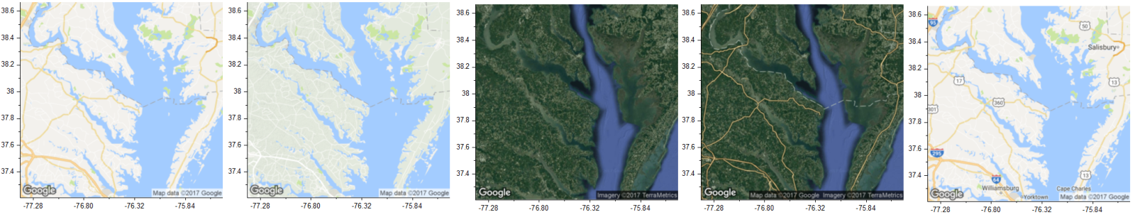
- Multiple map types available: Road map, Terrain, Satellite, Hybrid. Label option is also provided.
- Support for regions without full access to the APIs.
OPERATION
- Click on the Google Map Import icon to launch the dialog.
If the dialog is launched with a graph active, the map will be imported into either the active layer of that graph or a new graph.
If the dialog is launched with any other window (such as worksheet) active, the map will be imported into a new graph.
- Use the edit box on top left to search for a location, or simply zoom and pan the map displayed on the right side to your desired location.
If you started the dialog from a graph, you can pick up the X and Y range of the active graph layer by clicking on the curved arrow icon located in the upper right corner of the red rectangle on the left panel.
- The map image size that will be imported, is limited to 640x640 pixels.
By default, the entire map displayed on the right side, or the central part of the display will be imported, depending on the size of the right panel.
To have more control over the import area, click the "Area within ROI Box" radio. This will place a red rectangle ROI on the map.
You can then drag to resize or move the rectangle. Only the map area displayed within the rectangle will then be imported.
When "Area within ROI Box" is selected, you can also click on the pencil icon next to this radio to set the boundary more precisely.
Please be aware that the maximum size is 640*640. The central part no larger than that will be imported when the ROI exceeds that boundary.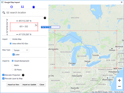
- There are 4 map types available: Road Map, Terrain, Satellite, and Hybrid. There is also a Label option which can be turned on or off (except for Satellite type).
- Google map images use Mercator projection.
Check the "Mercator Projection" checkbox to set the y axis scale for the Origin graph using a nonlinear formula so that the axis scale matches the Mercator projection.
If you have data points with specific latitude and longitude values plotted in the layer, these points will exactly match the map location when this checkbox is checked.
Otherwise the Y scale of the graph layer will be linear, and the axis scale will not match the map locations, particularly when the latitude values cover a large range.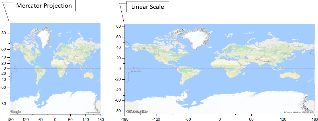
- Check the "Rescale Layer by Map" checkbox to resize the graph layer such that the axes lengths are in proportion with the X and Y ranges.
If unchecked, the layer will not be resized.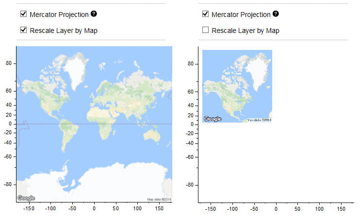
- If dialog was started from a graph, you will see two buttons:
Click on the "Import as New" button to create a new 2D/3D graph, or click on the "Import as Update" to import the map image into the active graph layer.
You can then continue to modify the map specifications and click the "Import as Update" button to replace the current map with a new map.
If the dialog was not started from a graph, you will see an Import button. Click this button to create a new graph with the map image. Once the graph is created, the "Import as New" and the "Import as Update" buttons will become available.
If the 3D Plane option is checked, this app creates a 3D graph with the map on the bottom of XY plane.
- Click the "Close" button to close the dialog.